NSW strategies and paddock restoration experience after drought
Description
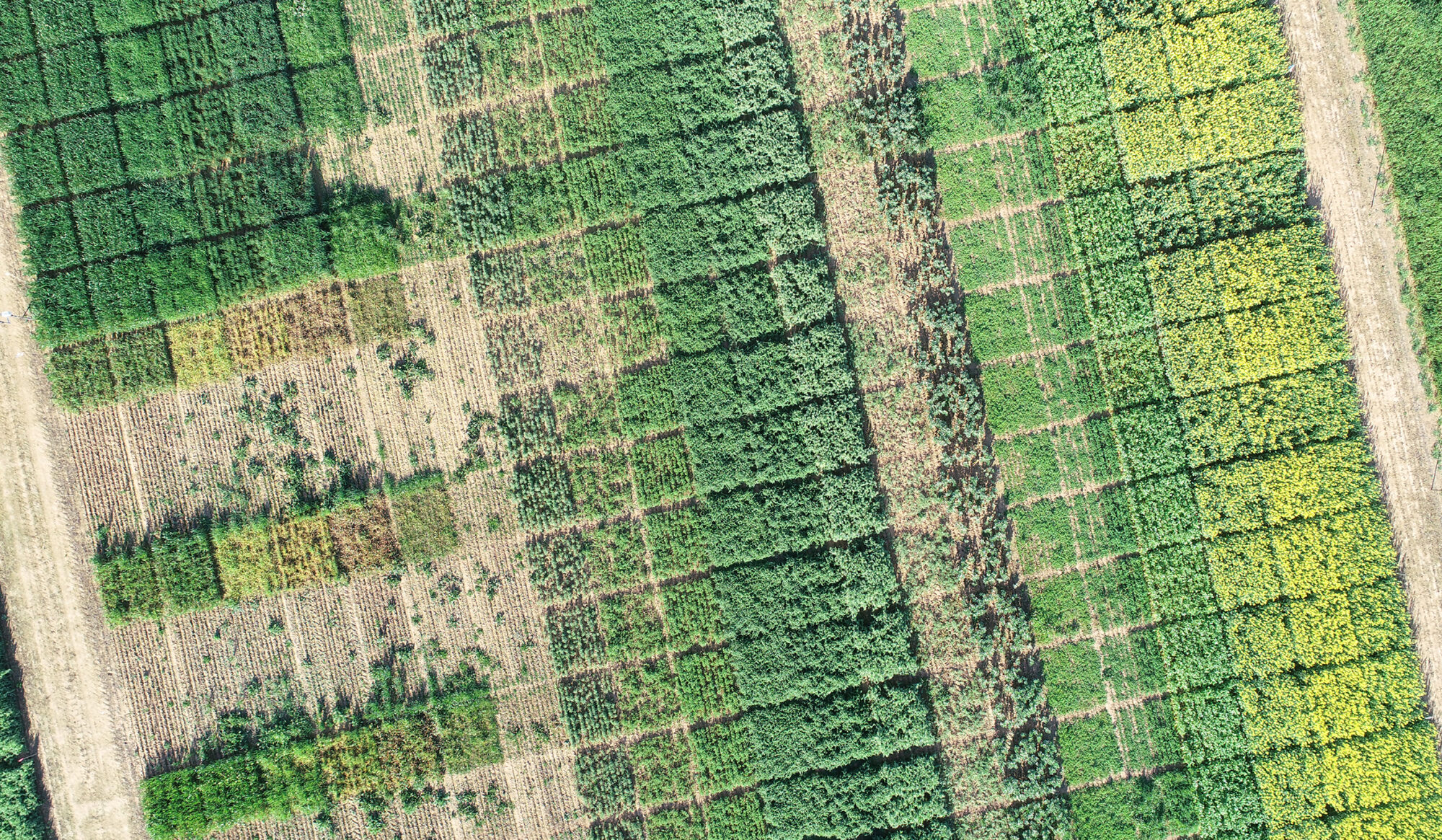
In this episode, Chris McDonough visits cousins Nigel Baird and Peter Baird in a paddock badly drifting in the 2018 and 2019 drought.
They’re talking about the GRDC investment ‘Practical tactics to improve ground cover and ensure soil preservation following successive low rainfall seasons.’
The Baird’s is a remarkable story of recovery. Following an extended period of drought, which in itself is bad enough, thousands of kangaroos descended from station country to take away any remaining ground cover, and this caused devastating wind erosion.
Since then Nigel and Peter have been working really hard to get the paddock back to where it was before the drought. Their success now just goes to show what can be done with a bit of hard work and determination.
To view the case studies from the project visit the GRDC website click here
To view the podcast transcript click here
Erosion Victoria, December 2021
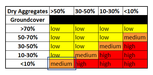
Second visit during the 2021 Summer season to reassess the Victorian site locations from Autumn. Monitoring erosion risk based on dry aggregates and groundcover percentages.
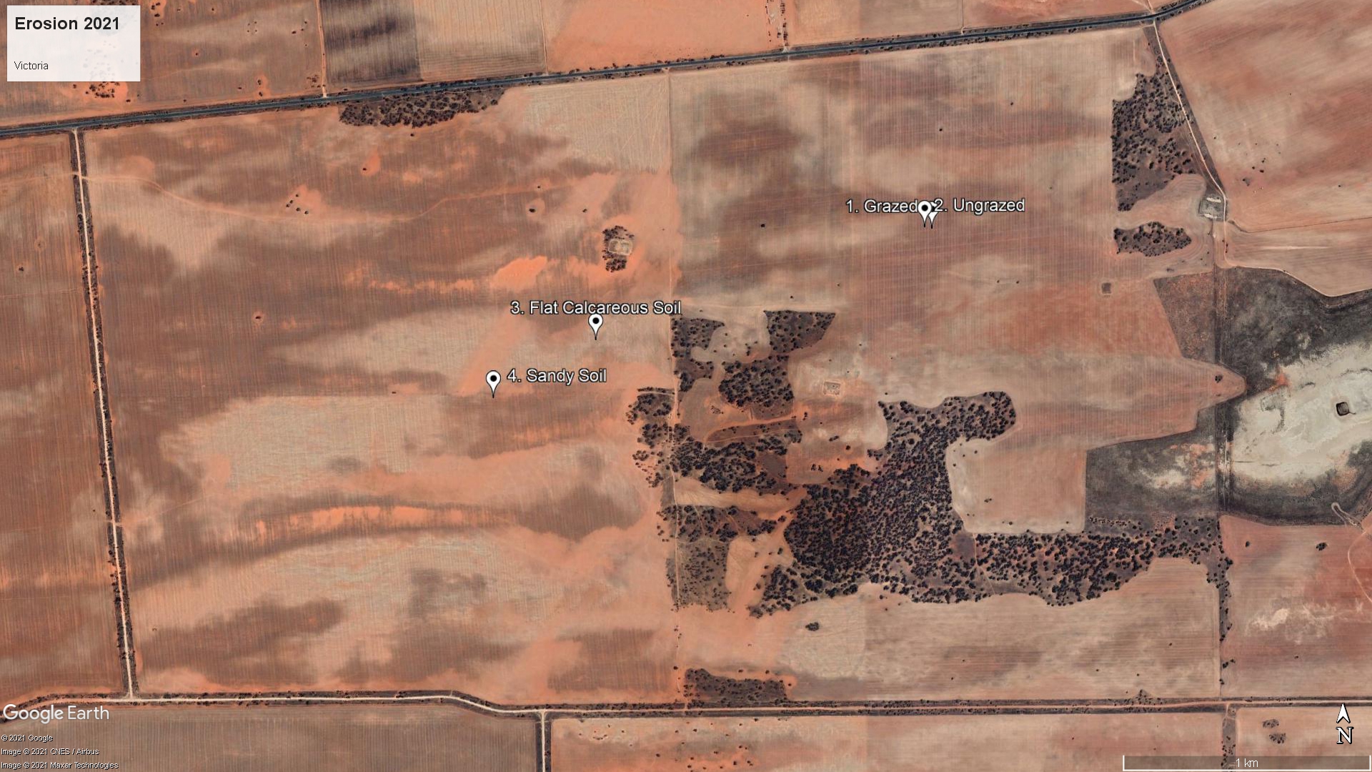
This farm is located west of Merbein South in the Millewa.
Victoria, Grazed and Ungrazed
1. Grazed is a sandy loam which was bare through 2019, but established a crop in 2020 and where electric fencing was used to protect the eastern side of the paddock from grazing. 2. Ungrazed is a sandy loam on the western grazed side of the paddock directly adjacent to 1. Grazed. Summer monitoring showed 1. ground cover of 46% and dry aggregate of 24% with a medium risk of erosion and 2. Ungrazed with ground cover of 67% and dry aggregate of 39% with a low risk of erosion


Summer 2021 – 360 Virtual Site
Compare to Autumn 2021 – Initial site visit here
Victoria, Flat Calcareous Soil
Flat Calcareous Soil is a poor calcareous sandy loam flat that blew through 2018 and 2019 but established crop in 2020. Being near sheep feeders it has attracted reasonable grazing pressure and sheep tracks. Summer monitoring showed 3. Flat Calcareous Soil with ground cover of 27% and dry aggregate of 49% with a medium risk of erosion

360 Virtual Site
Victoria, Sandy Soil
Sandy Soil or Sandy Loam during Summer monitoring showed 4. Sandy Soil with ground cover of 48% and dry aggregate of 27% with a medium risk of erosion

360 Virtual Site
Acknowledgments

This project “Practical tactics to improve ground cover and ensure soil preservation following successive low rainfall seasons” (MSF2010-002SAX) has been funded by GRDC.
Thank you to our landholder collaborators Ben Pollard, NSW, and Chris Hunt, VIC, for their time and input.
Erosion New South Wales, December 2021
Second visit during the 2021 Summer season to reassess the New South Wales site locations from Autumn. Monitoring erosion risk based on dry aggregates and groundcover percentages.
This farm is located northwest of Wentworth, with very low rainfall and high kangaroo pressure during drought.

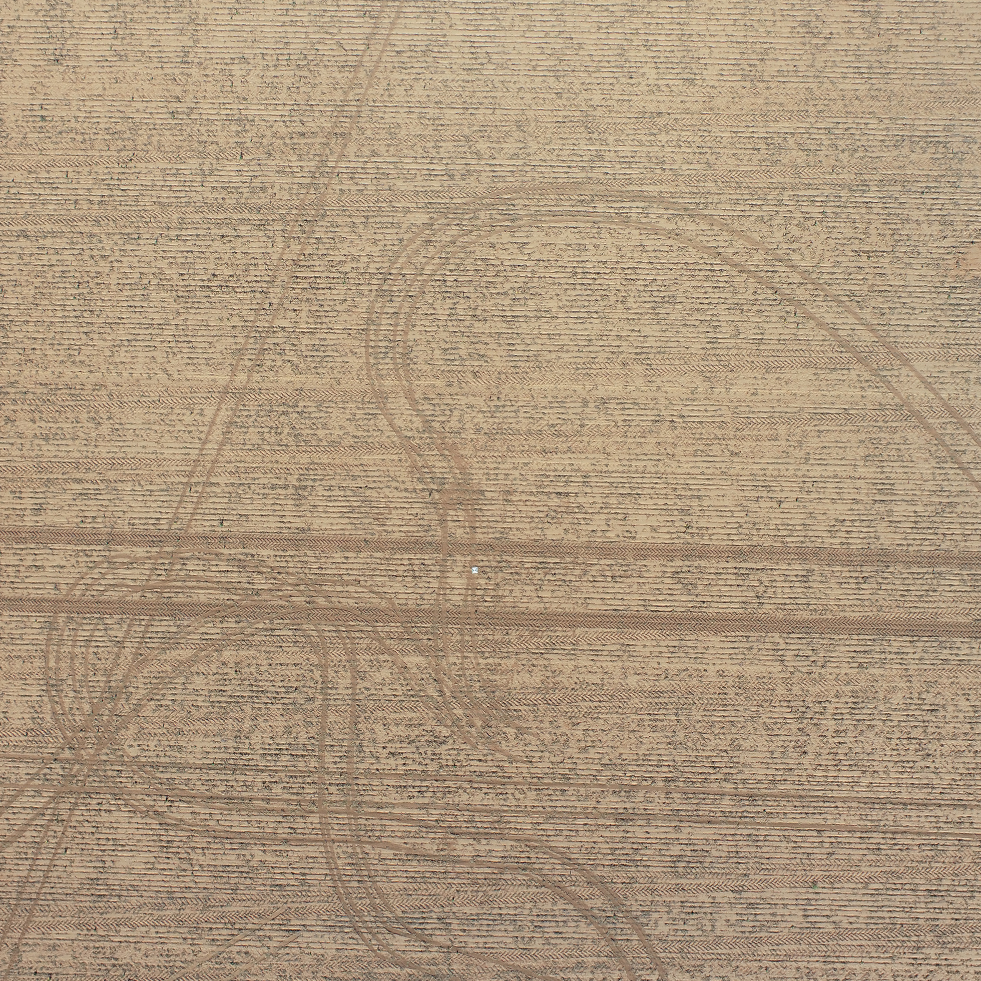
New South Wales, Calcareous Soil
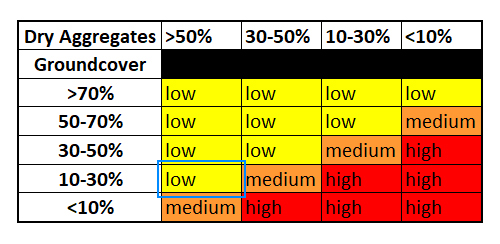
Calcareous Soil is described as the poor calcareous loam that grows very poorly in dry years and is very prone to wind erosion. Summer monitoring ground cover of 16% and dry aggregate of 43% with a medium risk of erosion

360 Virtual Site
New South Wales, Low Graze
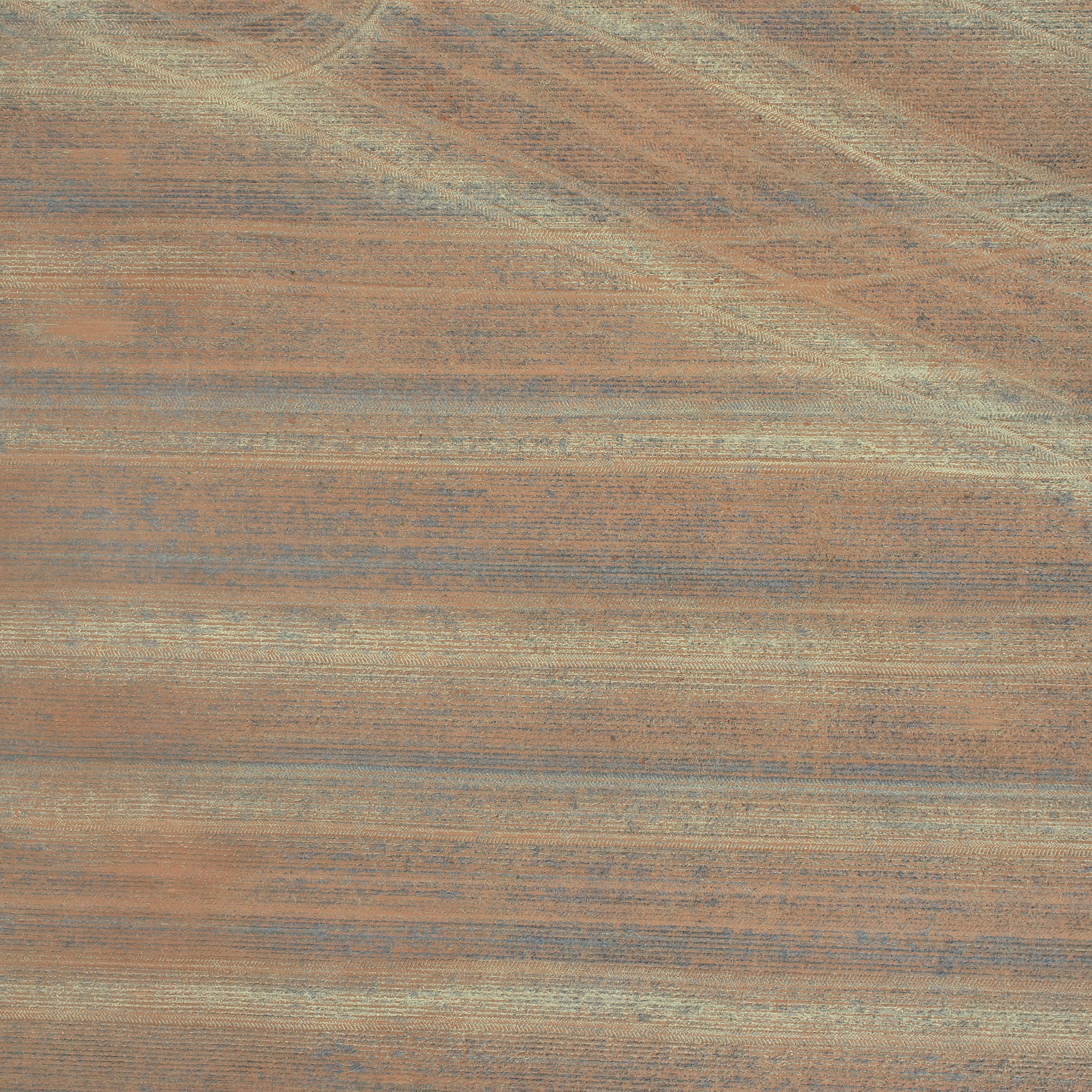
Low Graze is a sandy loam rise at the north end of the paddock that would have attracted the least amount of grazing since harvest. During the drought years kangaroos came through from the north baring out this area and contributing to the erosion. It is intended to compare this with site 4. High Graze which is on a similar soil type, but in an area of higher sheep activity. Summer monitoring showed ground cover of 74% and dry aggregate of 30% with a low risk of erosion

360 Virtual Site
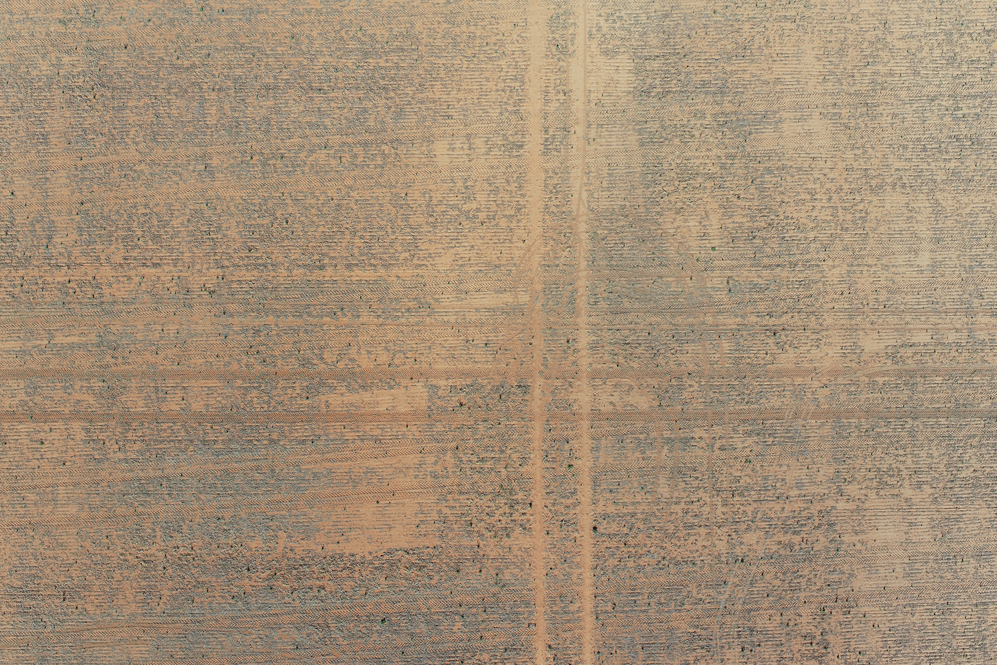
New South Wales, Eroded Mid Slope
Eroded Mid Slope is an exposed mid slope that has lost top soil down to a clay base, resulting in very patchy crop growth in 2020. This means that it has a high dry aggregation, but not for the right reasons. The farmer is looking to drag some sand back over this site to be able to re-establish crop growth. Summer monitoring showed ground cover of 9% and dry aggregate of 60% with a low risk of erosion
360 Virtual Site
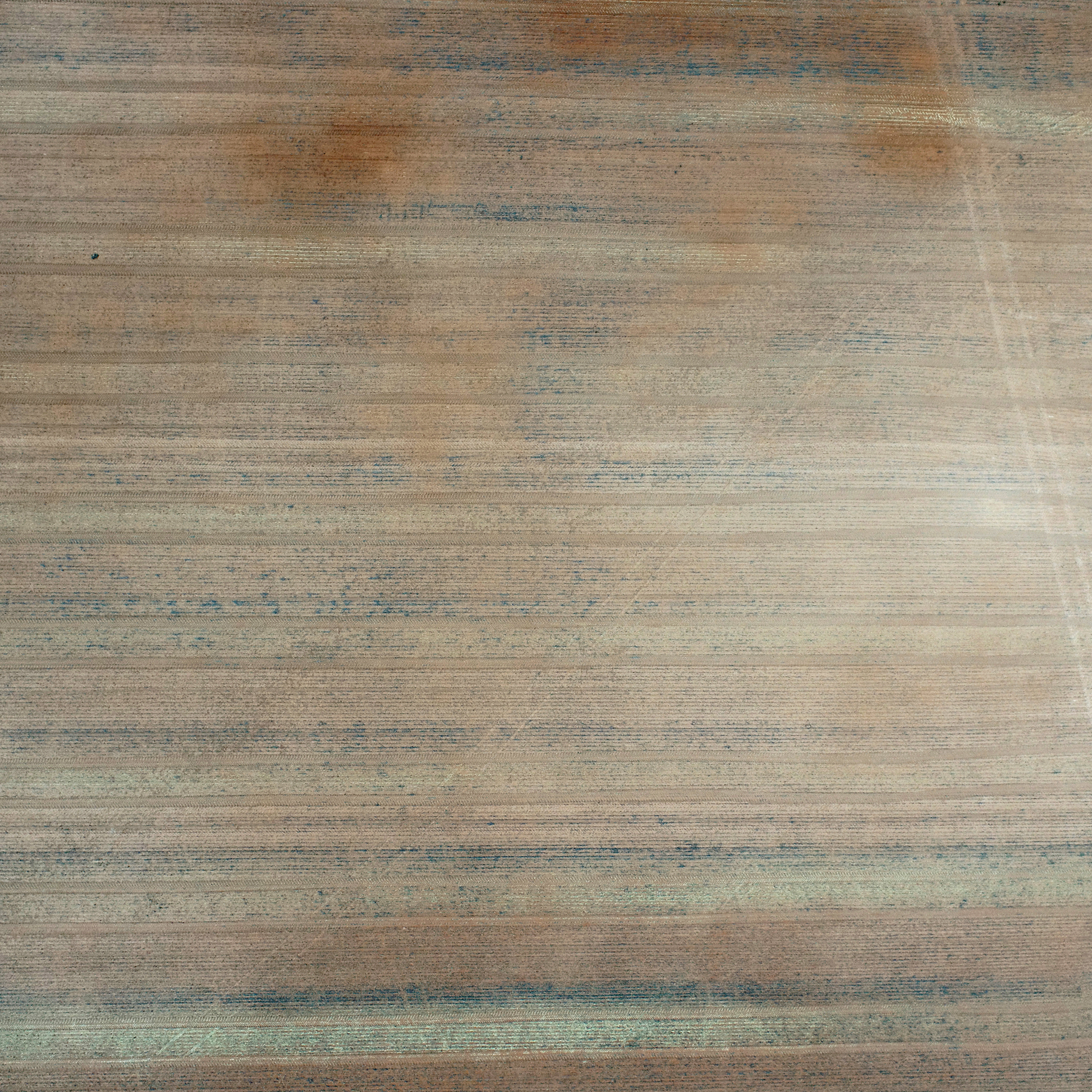
New South Wales, High Graze
High Graze is within the same paddock but at the south eastern corner near a trough, thus attracting far more grazing activity since crop harvest on this sandy loam area. Summer monitoring showed ground cover of 76% and dry aggregate of 26% with a low risk of erosion

360 Virtual Site
Acknowledgments
This project “Practical tactics to improve ground cover and ensure soil preservation following successive low rainfall seasons” (MSF2010-002SAX) has been funded by GRDC.
Thank you to our landholder collaborators Ben Pollard, NSW, and Chris Hunt, VIC, for their time and input.
Erosion New South Wales, March 2021
Initial visit during the 2021 Autumn season to assess the New South Wales site locations. Monitoring erosion risk based on dry aggregates and groundcover percentages.
This farm is located northwest of Wentworth, with very low rainfall and high kangaroo pressure during drought.
New South Wales, Calcareous Soil
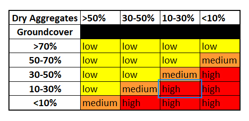
Calcareous Soil is described as the poor calcareous loam that grows very poorly in dry years and is very prone to wind erosion. Autumn monitoring showed a residue height of 25cm, ground cover of 32% and dry aggregate of 48% with a low risk of erosion

360 Virtual Site
New South Wales, Low Graze
Low Graze is a sandy loam rise at the north end of the paddock that would have attracted the least amount of grazing since harvest. During the drought years kangaroos came through from the north baring out this area and contributing to the erosion. It is intended to compare this with site 4. High Graze which is on a similar soil type, but in an area of higher sheep activity. Autumn monitoring showed a residue height of 28cm, ground cover of 69% and dry aggregate of 22% with a low risk of erosion

360 Virtual Site
New South Wales, Eroded Mid Slope
Eroded Mid Slope is an exposed mid slope that has lost top soil down to a clay base, resulting in very patchy crop growth in 2020. This means that it has a high dry aggregation, but not for the right reasons. The farmer is looking to drag some sand back over this site to be able to re-establish crop growth. Autumn monitoring showed a residue height of 6cm, ground cover of 14% and dry aggregate of 66% with a low risk of erosion
360 Virtual Site
New South Wales, High Graze

High Graze is within the same paddock but at the south eastern corner near a trough, thus attracting far more grazing activity since crop harvest on this sandy loam area. Autumn monitoring showed a residue height of 20cm, ground cover of 59% and dry aggregate of 17% with a low risk of erosion
360 Virtual Site
Acknowledgments
This project “Practical tactics to improve ground cover and ensure soil preservation following successive low rainfall seasons” (MSF2010-002SAX) has been funded by GRDC.
Thank you to our landholder collaborators Ben Pollard, NSW, and Chris Hunt, VIC, for their time and input.
Erosion Victoria, March 2021
Initial visit during the 2021 Autumn season to assess the Victorian site locations. Monitoring erosion risk based on dry aggregates and groundcover percentages.
This farm is located west of Merbein South in the Millewa.
Victoria, Grazed and Ungrazed
1. Grazed is a sandy loam which was bare through 2019, but established a crop in 2020 and where electric fencing was used to protect the eastern side of the paddock from grazing. 2. Ungrazed is a sandy loam on the western grazed side of the paddock directly adjacent to 1. Grazed. Autumn monitoring showed 1. Grazed with a residue height of 9cm, ground cover of 63% and dry aggregate of 25% with a low risk of erosion and 2. Ungrazed with a residue height of 1cm, ground cover of 13% and dry aggregate of 19% with a high risk of erosion
360 Virtual Site
Compare to Autumn 2021 – Initial site visit here
Victoria, Flat Calcareous Soil
Flat Calcareous Soil is a poor calcareous sandy loam flat that blew through 2018 and 2019 but established crop in 2020. Being near sheep feeders it has attracted reasonable grazing pressure and sheep tracks. Autumn monitoring showed 3. Flat Calcareous Soil with a residue height of 1cm, ground cover of 13% and dry aggregate of 19% with a low risk of erosion
360 Virtual Site
Victoria, Sandy Soil
Sandy Soil or Sandy Loam during Autumn monitoring showed 4. Sandy Soil with a residue height of 11cm, ground cover of 47% and dry aggregate of 22% with a low risk of erosion
360 Virtual Site
Acknowledgments
This project “Practical tactics to improve ground cover and ensure soil preservation following successive low rainfall seasons” (MSF2010-002SAX) has been funded by GRDC.
Thank you to our landholder collaborators Ben Pollard, NSW, and Chris Hunt, VIC, for their time and input.